The biggest waves on the Great Lakes

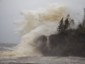
A massive wave pounding the shore along Lake Michigan, 2018.
A massive wave pounding the shore along Lake Michigan, 2018. https://www.boreal.org/2018/10/11/181867/photo-gallery-winds-whip-up-20-foot-waves-on-lake-superior

The Great Lakes, though their water is fresh, are so large they are often described as inland seas. Collectively, the Great Lakes region is sometimes called the “Third Coast”1 — and given its 5,300 miles of coastline2, it’s more than just a branding attempt to put the area on equal footing with the East and West coasts. But just how far does the comparison extend?

Far enough: even the lesser Great Lakes have seen waves large enough to make even the saltiest of sailors blanch. Waves on Lake Michigan can reach 20 to 23 feet3. More than 100 meteotsunamis — tsunami-like waves generated by rapid changes in barometric pressure — occur across the Great lakes each year. And in October 2017, the Great Lakes Observing System’s buoys recorded the largest waves it had ever detected: 28.8 feet on Lake Superior4. (The system’s records date back to 1979.)

Below, you can see footage of some truly monstrous waves on Lake Superior from 2018:
Share

Freak summer hailstorm buries Mexican city under feet of ice

Hail is not unheard of in severe summertime thunderstorms. And yet you definitely don’t expect a city in southwestern Mexico to be completely buried under multiple feet of ice in late June. “Incongruous” is a word that readily comes to mind!

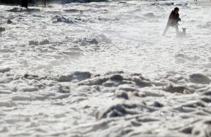
Ice-covered streets in Guadalajara, Mexico, June 30 2019. (Ulises Ruiz/AFP/Getty Images)

From CNN:

Guadalajara had been enjoying a sweaty summer for the past few weeks until the weekend brought a shocking surprise.

The Mexican city woke up Sunday morning to more than 3 feet of ice in some areas after a heavy hailstorm swept through the region.

Now, that sounds like a lot. But the visuals are even more striking. Check out video footage of the ice below:

Climate change, anyone?

Share

Huge, mysterious hole opens up in Antarctica

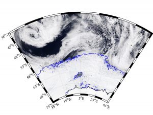
Image: MODIS-Aqua via NASA Worldview; sea ice contours from AMSR2 ASI via University of Bremen
An image of the hole in the ice (the blue outline within the icy area).

A massive, 30,000 square mile hole has just opened up in the Antarctic ice. (For reference, that’s roughly the size of the state of Maine, the surface of Lake Superior, or the entire nation of Belgium.) A hole such as this — an area of open water surrounded by sea ice — is called a polynya. This particular polynya is located in the Weddell Sea, and while its appearance is puzzling, it is not unprecedented: a similar hole was observed in the region in the 1970s. Precisely what led to the formation of the Weddell Sea polynya is unknown. A typical polynya forms close to open water; this one, however, is “deep in the ice pack” and thus “must have formed through other processes that aren’t understood.”1


While scientific data on the 1970s Weddell Sea polynya is limited to a few photographs taken by early satellites, technological advances since that time offer researchers greater ability to study — and perhaps understand — the hole’s recurrence. As to precisely what caused this hole to open up, I have my own theory:

Share

Boston’s snow pile STILL hasn’t melted.

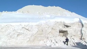
It’s nearly July, and while Boston’s massive mound of snow has certainly shrunk since its heyday, it seems likely that it will take at least a few more weeks before the last of it has melted away. Check out these pics from Twitter:

Before: Boston's snow mound at its height in February.
Before: Boston’s snow mound at its height in February.
After: Boston's snow mound in June, glory days long behind it.
After: Boston’s snow mound in June, glory days long behind it.

Source: http://www.msn.com/en-us/news/offbeat/bostons-nasty-snow-pile-still-hasnt-melted/ar-AAcaW12

Share

It’s raining spiders in Australia

Australia, the Land Down Under, the place where everything is poisonous, just got even more terrifying. You read the headline right: it is raining spiders in Australia:

Millions of tiny spiders recently fell from the sky in Australia, alarming residents whose properties were suddenly covered with not only the creepy critters, but also mounds of their silky threads. But that’s not where the frightful news ends: Experts say that such arachnid rains aren’t as uncommon as you might think.


Of course the question, then, is why is it raining spiders in Australia? (Tautological answers will not be accepted.) The answer is just as unsettling as the phenomenon itself. According to Rick Vetter, a retired arachnologist at the University of California, Riverside, witnesses

likely saw a form of spider transportation known as ballooning. “Ballooning is a not-uncommon behavior of many spiders. They climb some high area and stick their butts up in the air and release silk. Then they just take off,” Vetter told Live Science. “This is going on all around us all the time. We just don’t notice it.”

Next time I travel to Australia, remind me to bring an umbrella.

Share