Record-breaking rogue wave detected near Vancouver Island

Rogue waves, not to be confused with tsunamis, meteotsunamis, or tidal waves, are “unpredictable and suddenly appearing surface waves that can be extremely dangerous.” These waves occur in open water, not close to shore, and can be more than double the height of prevailing waves in the vicinity.

The Great Wave off Kanagawa
The Great Wave off Kanagawa (1831), the first print of Japanese artist Hokusai’s series Thirty-six Views of Mount Fuji. Sometimes thought to be a tsunami, it is more likely a rogue wave.

Scientists recently confirmed the largest rogue wave ever detected — in relative terms, at least — not far from Vancouver Island. There, a lone sensor buoy recorded a monstrous 58-foot wave, nearly three times larger than prevailing waves. From Smithsonian Magazine:

A wave the height of a four-story building was recorded off the coast of Vancouver Island, and scientists say it’s “the most extreme rogue wave ever recorded.” The 58-foot-tall giant, which appeared off the coast of Ucluelet, British Columbia, on November 17, 2020, is described in [a February 2022 article in] the journal Scientific Reports.

“Only a few rogue waves in high sea states have been observed directly, and nothing of this magnitude,” lead author Johannes Gemmrich, an oceanographer at the University of Victoria in British Columbia, says in the statement. “The probability of such an event occurring is once in 1,300 years.”

Interestingly, rogue waves were long thought to be the stuff of seafaring superstition — tall tales spun by generations of sailors, but without a basis in modern science. Much like giant squids, however, myth turned out to be reality: in 1995, a laser rangefinder aboard a North Sea oil platform detected an 84-foot rogue wave, double the significant wave height in the area. Scientists have taken the phenomenon seriously since.
Share

Huge, mysterious hole opens up in Antarctica

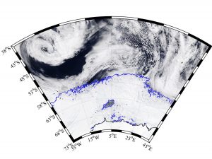
Image: MODIS-Aqua via NASA Worldview; sea ice contours from AMSR2 ASI via University of Bremen
An image of the hole in the ice (the blue outline within the icy area).

A massive, 30,000 square mile hole has just opened up in the Antarctic ice. (For reference, that’s roughly the size of the state of Maine, the surface of Lake Superior, or the entire nation of Belgium.) A hole such as this — an area of open water surrounded by sea ice — is called a polynya. This particular polynya is located in the Weddell Sea, and while its appearance is puzzling, it is not unprecedented: a similar hole was observed in the region in the 1970s. Precisely what led to the formation of the Weddell Sea polynya is unknown. A typical polynya forms close to open water; this one, however, is “deep in the ice pack” and thus “must have formed through other processes that aren’t understood.”1


While scientific data on the 1970s Weddell Sea polynya is limited to a few photographs taken by early satellites, technological advances since that time offer researchers greater ability to study — and perhaps understand — the hole’s recurrence. As to precisely what caused this hole to open up, I have my own theory:

Share

World’s deepest “blue hole” discovered

It’s located near the Xisha Islands (also known as the Paracel Islands) in the South China Sea.

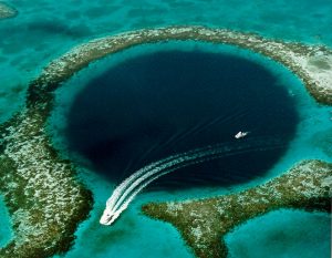
(Blue holes are underwater caverns or sinkholes, typically formed in shallow seabeds made of carbonate rock such as limestone. They can be hundreds of feet deep, and much deeper than surrounding waters, leading to dramatic photographs as seen here.)

From CBS:Great_Blue_Hole

A new exploration of a legendary blue hole in the South China Sea has found that the underwater feature is the deepest known on Earth.

According to Xinhua News, Dragon Hole, or Longdong, is 987 feet (300.89 meters) deep, far deeper than the previous record holder, Dean’s Blue Hole in the Bahamas.

Read more here!

Share